Water
03 Apr 2019 - Tansy Arron-Walker
An overview of the water sources available to us, and our plans for water management.
Sources
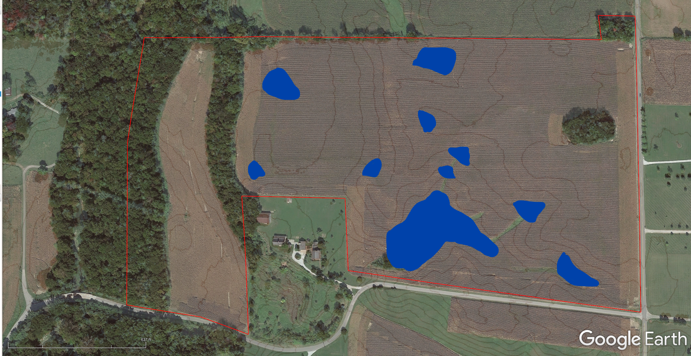
Our western boundary is adjacent to Conns Creek.
There are multiple springs on our neighbors land, producing roughly 50Gallons/minute. These run off across the south west corner of our land and into Conns Creek.
In addition, there are multiple pond sites and 40+ inches of rain every year.
Starting Status
At the moment the soil infliltration rates are insufficient to cope with the rainfall and given the current tillage and herbicide use there are areas of erosion visible, particularly on the south eastern quadrent where the land is moderately steep.
Goals
- Slow, store and infiltrate all the water that falls on our land. Spread it evenly everywhere.
- Ensure suffient water is available in the right places for crops and livestock.
- Prevent erosion and mitigate flooding events for those downstream of us.
- Mitigate contaminated runoff from adjacent land without adversely affecting their water situation. (don’t turn the neighbors place into a swamp.)
Plans
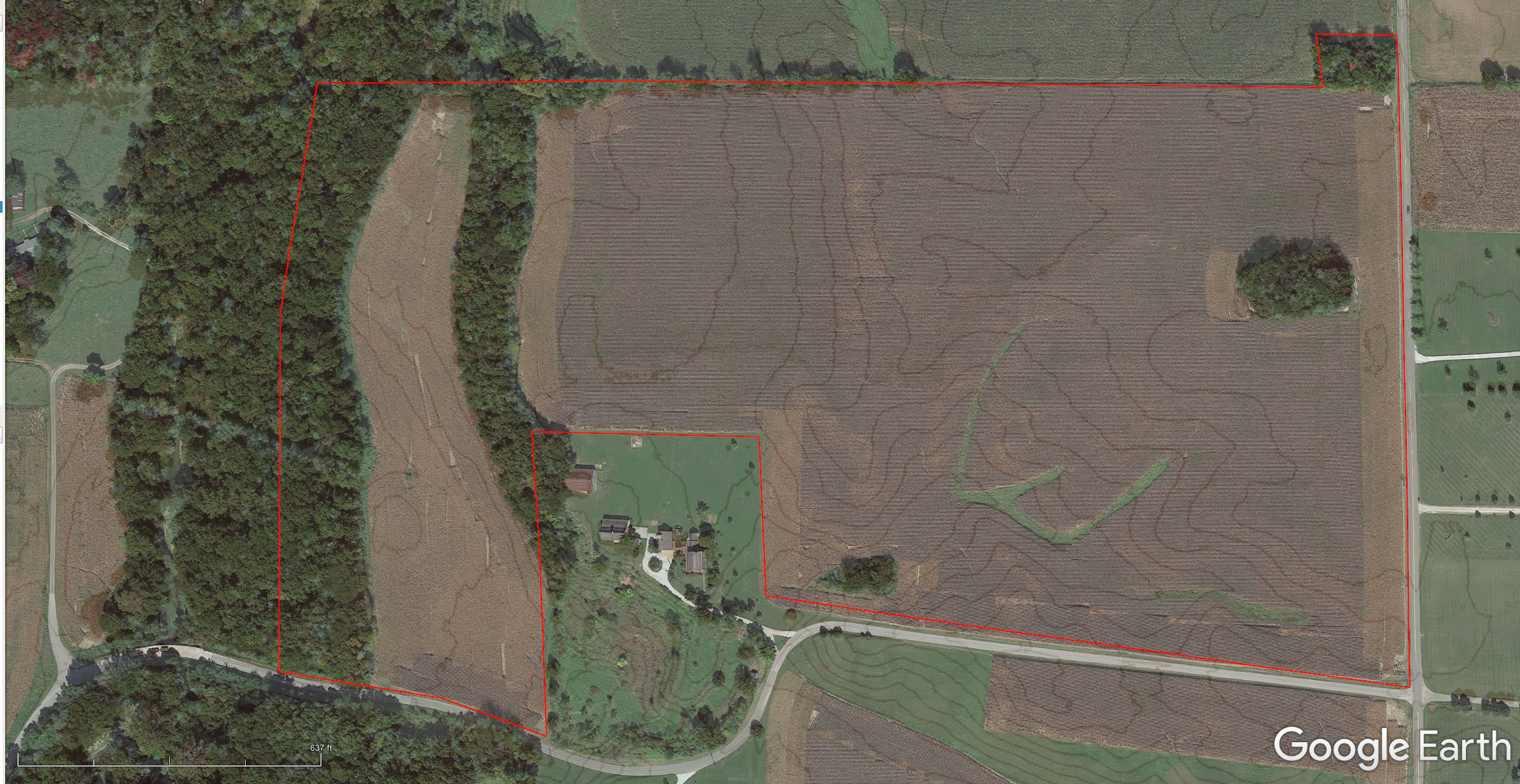
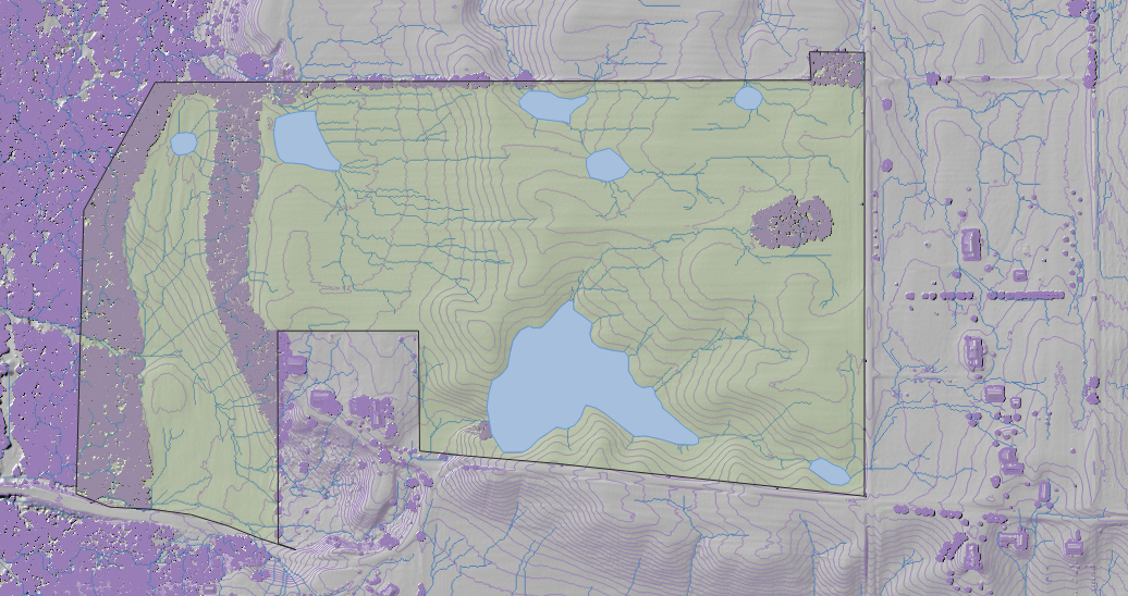
I used QGIS to analyze lidar data of the site. This let me calculate where the runoff channels are.

Lidar data is really awesome for this kind of planning. you can see on all these maps I’ve used the data to generate 50cm contour lines. The contour lines on the google earth images were also generated using QGIS and lidar, my next best bet was a 10ft contour, so this is a massive improvement.
This makes it particularly obvious why my mother in laws driveway washes out every time it rains.
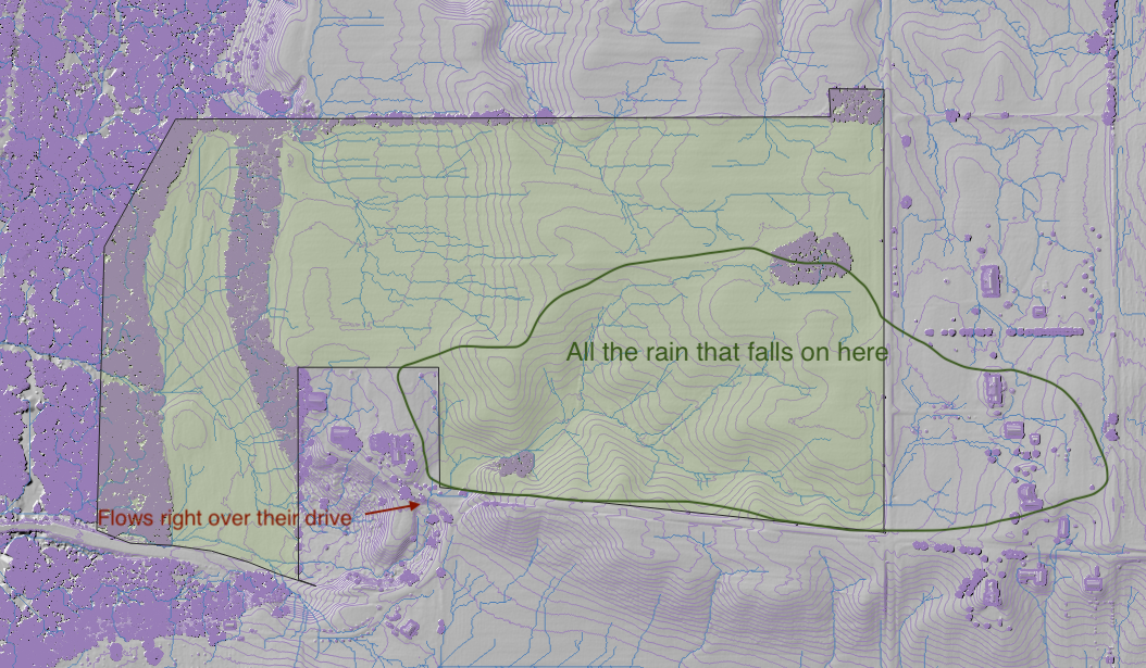
I can also see that there are only a few places where water flows onto the property.
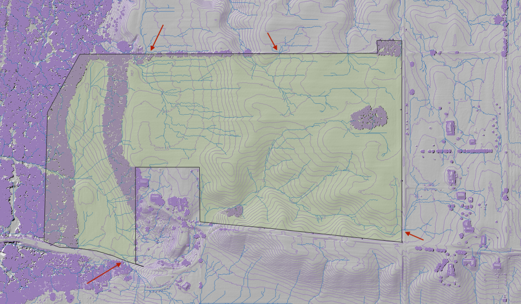 On the North boundary, there are two places where water flows onto the farm and in both cases it leaves again almost immediately. The land to our north is conventionally farmed corn/soy, so this is one place there may be herbicides/pesticides in the runoff.
On the East boundary, in the South corner we get runoff from two of our neighbors across the street.
On the South boundary water flows down the hill from the cemetary and appears to cross the road. I haven’t observed this myself and I think this water might not actually cross the road. The lidar data sees the world only from above and is looking at the elevation of the trees overhanging the road. I believe there is a ditch under the trees, but will have to check next time we visit.
One place I haven’t highlighted is where water flows from my in-laws place onto our land. They have several springs that flow continuously, which would drain across our west field but are currently diverted through a tile. The vast majority of the rain runoff that comes via their place travels from our land, to theirs, and back to ours again.
Ideally where ever water runs onto our land from elsewhere we’ll have a settling/filtering pond to help mitigate any contaminants before they get a chance to be taken up by our plants and animals.
There’s one particularly good site for a large water reservoir, suitable for swimming, fishing and dealing with rainfall events that currently wash out our neighbors driveway.
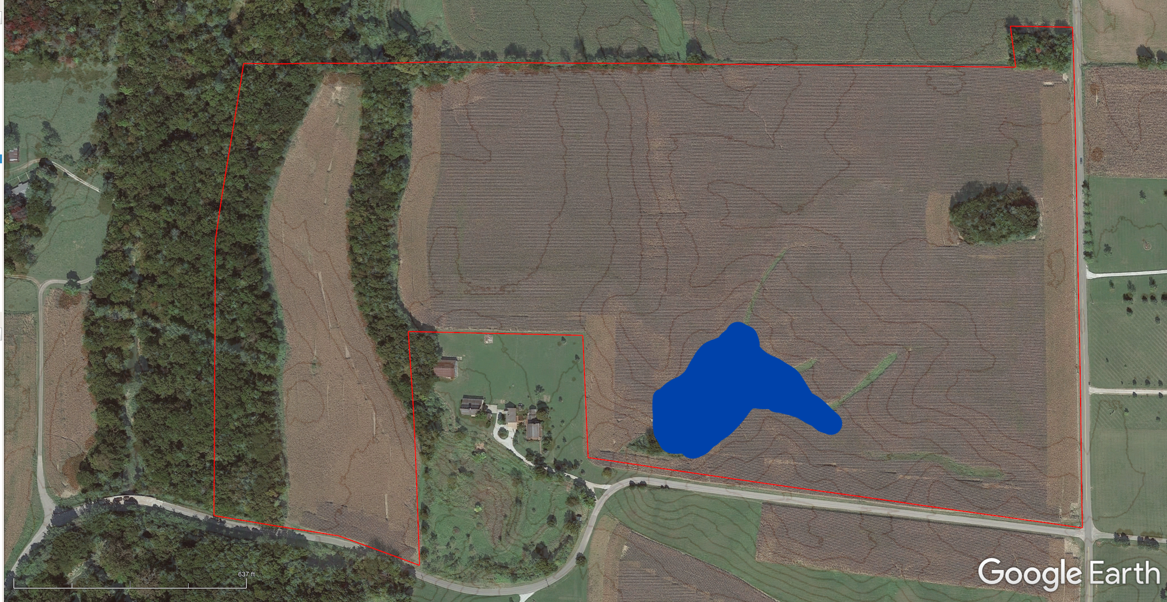
There are a number of secondary spots suitable for smaller or transient ponds. We haven’t quite nailed down exactly where they should all be.
 So I keep playing with it.
We’ll also want to subsoil and create swales to spread and slow water. These will be planted with rows of trees and are a key part of our silvopasture plans. The idea is to lay out 30 foot parallel lines with a 1% slope from the valley to the ridge. (0% - 4% if necessary.) I’m having trouble drawing these lines accurately in QGIS and there must be a way to do it programatically, but I haven’t figured it out yet. If anyone knows how to do this I’m all ears! (I’m also talking with Quantum Land Design as they can apparently do both the design and convert the plan into something bulldozers/tractors understand. RTK machinery is seriously cool.)
Another main component of our water management plan is to substantially improve our infiltration rates by building organic matter in the soil, planting deep rooting plants (trees, tillage raddish), and encouraging earth worms and burrowing animals.
Smaller scale plans such as troughs, water lines, rain barrels and so on will come later. USDA